Galerie d'images
Toutes les images de la base — taxons, formations et intervalles géologiques.
⚠ La fonctionnalité de récupération des images est en cours de test, des images non pertinentes peuvent apparaître.
95 image(s)


A render of Miolingian (Drumian) earth with focus on the continent of Laurentia, a cyclone is visible to the north. Intended to represent Wheeler Shale deposition


A mollweide map of Earth 21,000 years ago, overlayed by a black outline of present-day countries in their respective locations.
A mollweide map of Earth 21,000 years ago, overlayed by a black outline of present-day countries in their respective locations.


An equirectangular map of the world 5 million years ago, during the Zanclean age.

A mollweide map of Earth 5 million years ago, overlayed by a black outline of present-day countries in their respective locations.

An equirectangular map of the world 10 million years ago, during the Tortonian Age.

A Mollweide map of Earth 15 million years ago, overlayed by a black outline of present-day countries in their respective locations.
A Mollweide map of Earth 15 million years ago, overlayed by a black outline of present-day countries in their respective locations.
A Mollweide map of Earth 15 million years ago, overlayed by a black outline of present-day countries in their respective locations.

A mollweide map of Earth 30 million years ago, overlayed by a black outline of present-day countries in their respective locations.

Map of the Earth 50 mya in the Ypresian stage of the Eocene

A mollweide map of Earth 60 million years ago, overlayed by a black outline of present-day countries in their respective locations.

A mollweide map of Earth 45 million years ago, overlayed by a black outline of present-day countries in their respective locations.
A mollweide map of Earth 45 million years ago, overlayed by a black outline of present-day countries in their respective locations.
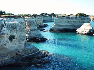
Torre Sant'Andrea

Opening of western Indian Ocean at 70 Ma: first oceanic crust between India and Madagascar.


A mollweide map of Earth 85 million years ago, overlayed by a black outline of present-day countries in their respective locations.

Palaeogeography of the Earth in Aptian, with location of Acrocanthosaurus fossils as green dots

Classical stratotype du Barremien (1963) a Angles (Alpes-de-Haute-Provence). Ce n'est pas le GSSP officiel.

A mollweide map of Earth 120 million years ago, overlayed by a black outline of present-day countries in their respective locations.

A mollweide map of Earth 105 million years ago, overlayed by a black outline of present-day countries in their respective locations.

Mollweide map of Earth 145 million years ago, with black outlines depicting countries in their locations

A mollweide map of Earth 155 million years ago, overlayed by a black outline of present-day countries in their respective locations.

Aalenian GSSP (Lower-Middle Jurassic boundary). Golden spike ceremony: July, 28th 2016. Fuentelsaz, Guadalajara, Spain

Mollweide map of Earth 180 million years ago, with black outlines depicting countries in their locations

Cliff Face East Quantoxhead

Mollweide map of Earth 200 million years ago, with black outlines depicting countries in their locations

A mollweide map of Earth 190 million years ago, overlayed by a black outline of present-day countries in their respective locations.

A mollweide map of Earth 170 million years ago, overlayed by a black outline of present-day countries in their respective locations.
A mollweide map of Earth 170 million years ago, overlayed by a black outline of present-day countries in their respective locations.

Mollweide map of Earth 205 million years ago, with black outlines depicting countries in their locations

Author: kaapitone

A mollweide map of Earth 220 million years ago, overlayed by a black outline of present-day countries in their respective locations.
A mollweide map of Earth 220 million years ago, overlayed by a black outline of present-day countries in their respective locations.

Lake Lugano seen from above Morcote (Ticino). In the middle: the village of Brusino Arsizio and the Monte San Giorgio. In the background: Monte Generoso.

Untere Sulfatschichten, Heilbronn-Formation, Mittlerer Muschelkalk, Löwenburg bei Braunsbach-Geislingen

A mollweide map of Earth 240 million years ago, overlayed by a black outline of present-day countries in their respective locations.

Naturdenkmal "Lange Anna" Helgoland – Die Aufnahme enstand bei einer abendlichen Bootsrundfahrt um die Insel Helgoland von Norden aus.


A mollweide map of Earth 250 million years ago, overlayed by a black outline of present-day countries in their respective locations.

A mollweide map of Earth 225 million years ago, overlayed by a black outline of present-day countries in their respective locations.


Zechstein unconformity and basal Zechstein beds (basal Werra-Formation, lower Upper Permian) including copper shale (brownish weathered), exposed on the upper level of the open cast mine Kamsdorf, near Saalfeld, Thuringia, Germany.

A mollweide map of Earth 255 million years ago, overlayed by a black outline of present-day countries in their respective locations.

Mollweide map of Earth 260 million years ago, with black outlines depicting countries in their locations

Mollweide map of Earth 270 million years ago, with black outlines depicting countries in their locations

A mollweide map of Earth 265 million years ago, overlayed by a black outline of present-day countries in their respective locations.

Mollweide map of Earth 295 million years ago, with black outlines depicting countries in their locations

A mollweide map of Earth 285 million years ago, overlayed by a black outline of present-day countries in their respective locations.

A mollweide map of Earth 275 million years ago, overlayed by a black outline of present-day countries in their respective locations.
A mollweide map of Earth 275 million years ago, overlayed by a black outline of present-day countries in their respective locations.

Stratotype of the Carboniferous system (Gzhel horizon) - Protected areas of Russia (5010231)

Mollweide Map of Earth 320 Million Years Ago, Black Outlines Depicting Countries in their locations

A mollweide map of Earth 310 million years ago, overlayed by a black outline of present-day countries in their respective locations.