Galerie d'images
Toutes les images de la base — taxons, formations et intervalles géologiques.
⚠ La fonctionnalité de récupération des images est en cours de test, des images non pertinentes peuvent apparaître.
2,398 image(s)

A plate tectonic reconstruction of Asia in 19 images. View centred on 0°,105°. Made using Gplates and the following data sets: Amante, C. and Eakins, B. W. 2009. ETOPO1 1 Arc-Minute Global Relief Model: Procedures, Data Sources and Analysis. NOAA Technical Memorandum NESDIS NGDC-24, 19. Wright, N., S. Zahirovic, R. D. Müller, and M. Seton (2013), Towards community-driven, open-access paleogeographic reconstructions: integrating open-access paleogeographic and paleobiology data with plate tectonics, Biogeosciences, 10, 1529-1541

A mollweide map of Earth 450 million years ago, overlayed by a black outline of present-day countries in their respective locations.

Earth during the Middle Ordivician Period @ 460 Ma. Gondwana is seen above the equator (Australia & South China) and bellow the equator (North China, Kazakh terranes, Tarim, Antartica, India, Madagascar, Africa and South America). Laurentia, Baltica & Sibera are seperate continents, with Avalonia on its way to collide Baltica to form the Calledonian Orogeny, and Acadia on its way to collide Laurentia to form the Acadian Orogeny. Legend: Dark blue = ocean Light blue = shallow seas Tan = landmass Black outlines = modern day coastlines showing their respective positions

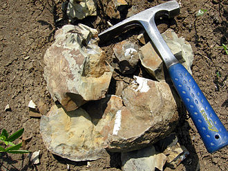
Rock from the Skiddaw Group, of Ordovician (Tremadocian) age, at Scawgill Bridge quarry in Cumbria, England, UK.

A mollweide map of Earth 480 million years ago, overlayed by a black outline of present-day countries in their respective locations.

A mollweide map of Earth 465 million years ago, overlayed by a black outline of present-day countries in their respective locations.
A mollweide map of Earth 465 million years ago, overlayed by a black outline of present-day countries in their respective locations.

A mollweide map of Earth 495 million years ago, overlayed by a black outline of present-day countries in their respective locations.
A mollweide map of Earth 495 million years ago, overlayed by a black outline of present-day countries in their respective locations.

A mollweide map of Earth 505 million years ago, overlayed by a black outline of present-day countries in their respective locations.


A mollweide map of Earth 530 million years ago, overlayed by a black outline of present-day countries in their respective locations.

A mollweide map of Earth 510 million years ago, overlayed by a black outline of present-day countries in their respective locations.


A mollweide map of Earth 600 million years ago, overlayed by a black outline of present-day countries in their respective locations.

A mollweide map of Earth 690 million years ago, overlayed by a black outline of present-day countries in their respective locations.

A mollweide map of Earth 750 million years ago, overlayed by a black outline of present-day countries in their respective locations.

This is a collage that represents three periods of Neoproterozoic and is composed of three images from Commons: File:Otavia antiqua 3D reconstruction.jpg represents Tonian period (1000-720 mya), marked by start of evolution of animals. File:AntarcticaDomeCSnow.jpg represents Cryogenian period (720-635 mya), marked by worldwide glaciations (aka "Snowball Earth"). File:Life in the Ediacaran sea.jpg represents Ediacaran period (635-541 mya), marked by first recognizable animal fauna - vendobionts.

A map of Proto-Rodinia on 1040 mya.

A reconstruction of the earth's continents during the Ectasian period, circa 1260 Ma.

A reconstruction of the earth's continents during the Calymmian period, circa 1590 Ma.

Banded fine-grained pyrite in shale from the Precambrian of Australia. (public display, Leadville Mining Museum, Leadville, Colorado, USA) A mineral is a naturally-occurring, solid, inorganic, crystalline substance having a fairly definite chemical composition and having fairly definite physical properties. At its simplest, a mineral is a naturally-occurring solid chemical. Currently, there are over 4900 named and described minerals - about 200 of them are common and about 20 of them are very common. Mineral classification is based on anion chemistry. Major categories of minerals are: elements, sulfides, oxides, halides, carbonates, sulfates, phosphates, and silicates. The sulfide minerals contain one or more sulfide anions (S-2). The sulfides are usually considered together with the arsenide minerals, the sulfarsenide minerals, and the telluride minerals. Many sulfides are economically significant, as they occur commonly in ores. The metals that combine with S-2 are mainly Fe, Cu, Ni, Ag, etc. Most sulfides have a metallic luster, are moderately soft, and are noticeably heavy for their size. These minerals will not form in the presence of free oxygen. Under an oxygen-rich atmosphere, sulfide minerals tend to chemically weather to various oxide and hydroxide minerals. Pyrite is a common iron sulfide mineral (FeS2). It’s nickname is “fool's gold”. Pyrite has a metallic luster, brassy gold color (in contrast to the deep rich yellow gold color of true gold - www.flickr.com/photos/jsjgeology/sets/72157651325153769/), dark gray to black streak, is hard (H=6 to 6.5), has no cleavage, and is moderately heavy for its size. It often forms cubic crystals or pyritohedrons (crystals having pentagonal faces). Pyrite is common in many hydrothermal veins, shales, coals, various metamorphic rocks, and massive sulfide deposits. The rock shown above consists of numerous bands of fine-grained pyrite interbedded with dark shale. Published research has shown that the pyrite is diagenetic, formed by sulfate reduction from sulfate-bearing groundwater that moved along bedding planes of the Urquhart Shale host rocks (see Painter et al., 1999). The sulfate source was evaporitic gypsum-anhydrite-barite in the same stratigraphic unit. Stratigraphy: Urquhart Shale, Mount Isa Group, Mesoproterozoic, ~1655 Ma Age of metamorphism: peak greenschist-facies metamorphism at ~1505 Ma during the Isan Orogeny Locality: Mount Isa Mines, northwestern Queensland, northeastern Australia Some info. from: Kawasaki & Symons (2010) - Dating of Mesoproterozoic metamorphism in the Mount Isa and George Fisher Zn-Pb-Cu-Ag deposits, Australia, by paleomagnetism. American Geophysical Union, Fall Meeting 2010, Abstract GP33C-0953. Painter et al. (1999) - Sedimentologic, petrographic, and sulfur isotope constraints on fine-grained pyrite formation at Mount Isa Mine and environs, northwest Queensland, Australia. Economic Geology 94: 883-912. Photo gallery of pyrite: www.mindat.org/gallery.php?min=3314

A reconstruction of the earth's continents during the Statherian period, circa 1740 Ma.

A reconstruction of the earth's continents during the early Orosirian, circa 2000 Ma.

This image shows a 2.1 billion year old rock containing black-banded ironstone. The rock weighs about 8.5 tons, and is approximately two meters high, three meters wide, and one meter thick. It was found in North America and belongs to the National Museum of Mineralogy and Geology, Dresden, Germany. The rock is located at +51°2'34.84" +13°45'26.67".


A collage depicting four major events during the Proterozoic eon: File:Snowball Huronian.jpg File:Ramathallus lobatus.png File:AntarcticaDomeCSnow.jpg File:Ediacaran ecosystem diorama NMNH.jpg

A reconstruction of the earth's continents during the middle Neoarchean, circa 2650 Ma.

Banded iron formation from the Precambrian of Wyoming, USA. (~10.9 cm across at its widest) Banded iron formations, or BIFs, are unusual, dense sedimentary rocks consisting of alternating layers of iron-rich oxides and iron-rich silicates. Most BIFs are Proterozoic in age (although some are Late Archean), and do not form today - they're “extinct”! Many specific varieties of iron formation are known, and some are given special rock names. For example, jaspilite is an attractive reddish & silvery gray banded rock consisting of hematite, red chert (“jasper”), and specular hematite or magnetite. Because of their age, most BIFs have been around long enough to have been subjected to one or more orogenic (mountain-building) events. As such, most BIFs are folded and/or metamorphosed to varying degrees. BIFs are known from around the world, but some of the most famous & extensive BIF deposits are found in the vicinity of North America’s Lake Superior Basin. Many BIFs have economic concentrations of iron and are mined. BIFs are the most important variety of iron ore on Earth. Some iron mines in west-central Wyoming exploit BIFs in the Goldman Meadows Formation, a Mesoarchean unit exposed in the Wind River Range. These rocks have been multiply metamorphosed during the Precambrian. The result of this metamorphism is highly contorted folding and fracturing. The rock shown above is a folded quartz-hematite-limonite meta-BIF. Stratigraphy: iron formation member (probably the upper iron formation member) of the Goldman Meadows Formation, upper Mesoarchean, 2.87 Ga (metamorphosed in the Archean at 2.8 Ga and in the Mesoproterozoic at 1.4 Ga) Geologic context: northwestern flank of the South Pass Greenstone Belt, southern Wind River Range Locality: Atlantic City Iron Mine (open-pit mine; sample possibly collected from tailings piles around the now-flooded pit) (E1/2 of section 26, T30N, R100W, Miners Delight 7.5' USGS topographic quadrangle), South Pass-Atlantic City Mining District, along Rt. 28, southwestern side of South Pass, north of Atlantic City, southwestern Fremont County, west-central Wyoming, USA (mine is at 42° 32' 45" North latitude, 108° 44' 33" West longitude)

Reconstruction of Vaalbara supercontinent

Greenlandite (fuchsite-quartz gneiss) (2.7 cm across at its widest) from the Precambrian of southwestern Greenland. Green = fuchsite; gray = quartz; a few small, scattered pyrite crystals (brassy gold-colored) are also visible. Attractive greenish-colored gneisses in southwestern Greenland that contain the minerals fuchsite (green) and quartz (gray) have been informally called greenlandite. Fuchsite is a chromian muscovite mica (K(Al,Cr)2AlSi3O10(OH,F)2 - potassium chromium hydroxy-fluoro-aluminosilicate); it is typically encountered in schistose rocks. Greenland greenlandite is part of a 3.8 billion year old, highly metamorphosed succession of rocks. These represent the oldest known supracrustal rocks on Earth (the oldest crustal Earth rocks include 4.03 billion year old Acasta Gneiss, 4.28 b.y. rocks from the eastern Hudson Bay area, and 4.45-4.55 b.y. rocks in the subsurface of Baffin Island, Canada). Locality: undisclosed locality in the Godthåbsfjord area or Nuuk area, southwestern Greenland. Age: Eoarchean boundary, 3.8 billion years.

Artist's impression of the Archean Eon.

This artist's concept shows a celestial body about the size of our moon slamming at great speed into a body the size of Mercury. NASA's Spitzer Space Telescope found evidence that a high-speed collision of this sort occurred a few thousand years ago around a young star, called HD 172555, still in the early stages of planet formation. The star is about 100 light-years from Earth.

Munkaterület

Locality map for Australian eurypodan thyreophoran fossils. 1, Stegosaurian? footprint (QM F5701), Walloon Coal Measures, Balgowan Colliery, Balgowan (Bajocian–Bathonian); 2, Minmi paravertebra holotype (QM F10329) (Molnar, 1980), Minmi Member, Bungil Formation (Valanginian–Barremian); 3, Thyreophoran trackways, Broome Sandstone, Dampier Peninsula, Western Australia (Valanginian–Barremian); 4, Ankylosauria indet. (see Barrett et al., 2010) ‘Flat Rocks’ Wonthaggi Formation (upper Hauterivian–Albian); 5, NMV P216739, ‘Lake Copco–Dinosaur Cove’ Eumeralla Formation (middle upper Aptian to lower middle Albian) (Barrett et al., 2010); 6, QM F33286; 7, AM F119849 and AM F35259; 8, Kunbarrasaurus ieversi gen. et sp. nov. (formerly Minmi sp.) (QM F18101); 9, QM F33565 and QM F33566; 10, QM F44324-28. Legend: Dark Green, Toolebuc Formation (late middle–early late Albian); Green, Allaru Formation (upper Albian–(?)lower Cenomanian); Light green, Mackunda Formation (upper Albian–lower Cenomanian); Lightest green, Winton Formation (late Albian–early Turonian).

Original figure caption: .mw-parser-output .smallcaps{font-variant:small-caps}The Middletown Slab covered with the Footprints of Carnivorous Dinosaurs. The tracks are in high relief. Additional notes: Most if not all of these tridactylous (i.e. three-toed) footprints/tracks (but not the actual trackmaker!) are referred to as Grallator or as Grallator-type trace fossils. “High relief” means that these are actually casts of footprints forming a positive relief on the lower surface of the sandstone slab (so-called positive hyporelief). The material that originally formed the mud over which the dinosaurs walked was too friable to be recovered from the quarry in one piece. The slab consists of so called ‘brownstone’ which is the trading name of the sandstone quarried at Middletown, Connecticut. This sandstone belongs to the Lower Jurassic Portland Formation of the Hartford Basin (“Connecticut Valley”) and thus to the upper part of the Newark Supergroup. The trackmakers probably were relatively small ‘primitive’ theropod dinosaurs (coelophysoids) such as Podokesaurus the remains of which were recovered from Lower Jurassic deposits of the Hartford Basin.


This cage protects the largest single piece of rock art, a battle scene.


Map of Grand Staircase-Escalante National Monument (GSENM), southern Utah (A), and generalized stratigraphic section of the upper Campanian Kaiprowits Formation (B). The approximate stratigraphic position of Akainacephalus johnsoni is located near the base of the middle unit within the Kaiparowits Formation. The map highlights the GSENM boundary (dashed line), showing the geological distribution and outcrops of the Cretaceous Kaiparowits, Wahweap, and Straight Cliffs formations. The red star indicates the Horse Mountain area, from which Akainacephalus johnsoni was recorded. Map and stratigraphic column modified from Roberts (2005). Radioisotopic dates used from Roberts, Deino & Chan (2005) and Roberts et al. (2013), respectively.

Psittacosaurus skeletal mount (Early Cretaceous, Jiufotang Formation) and unidentified Late Cretaceous dinosaur egg from Xixia, Hennan, on display in the Li Siguang Memorial Museum in Huangzhou.


(A) Map of Queensland showing the extent of Cretaceous outcrop. (B) Map of the location of Dig Site Three (type locality of Haliskia), and numerous other sites in the area from which pterosaur fossils have been collected.

Vista de la represa W. A. C. Bennett y del rio de La Paz desde el sur este.

Gren River Basin Stratigraphic Column

Dryolestidan mammal Crusafontia amoae sp. nov., MPZ CC2−1 M4 or M5, holotype, from the site of Cuesta Corrales 2, Colladico Blanco level, El Castellar Formation, Galve, Teruel, Spain in, occlusal (A), mesial (B), labial (C), distal (D), and lingual (E) views. The schematic drawing of C. amoae, in the box in the lower left−hand corner shows the main anatomical elements of the occlusal surface of a dryolestidan.

A trackway of the trace fossil Bifurculapes laqueatus (positive hyporelief, i.e. casts on the bottom surface of the bed) from the Early Jurassic East Berlin Formation (Hartford Basin) of Holyoke, Massachusetts (not the same specimen as this one). Scale is in cm.

Geological context of the Lower Cretaceous deposits of southeast England, focussing on the Purbeck Group and Wealden Supergroup. (A) Schematic geology of the Lower Cretaceous deposits of the Weald Sub-basin (southeast England), highlighting published spinosaurid finds (Charig & Milner, 1997; Salisbury & Naish, 2011; Turmine-Juhel et al., 2019). Based on Austen & Batten (2018: Fig. 2). Note that various additional spinosaurid teeth are known from the region but remain undescribed in detail (Fowler, 2007). (B) Simplified stratigraphic column of the Weald Group in southeast England, based on Batten & Austen (2011: Fig. 3.2). Note that the Grinstead Clay Formation, which subdivides the Tunbridge Wells Sands Formation in Batten & Austen (2011) and from which the “Suchosaurus cultridens” type specimen was discovered (Salisbury & Naish, 2011), is downgraded to a member of the latter formation in other works (Hopson, Wilkinson & Woods, 2008) and has not been included in this column. Spinosaurid silhouette courtesy of Dan Folkes (CC-BY 4.0).


Diagram depicting the currently named Dinosauria from the Early Cretaceous Cedar Mountain Formation of Utah. Dinosaur taxa: Cedarosaurus weiskopfae → Grand County locality.[1] Length = 15 meters.[2] Cedrorestes crichtoni → Dave's Camp Site locality.[3] Length = 6 meters.[4] Falcarius utahensis → Crystal Geyser Quarry & Suarez Site/Quarry localities.[5] Length = 5 meters.[5] Gastonia burgei → Gaston Quarry, Dalton Wells, Doelling's Bowl localities.[6] Length = 5 meters.[2] Geminiraptor suarezarum → Suarez Site/Quarry locality.[7] Length = 1.5 meters.[4] Hippodraco scutodens → Andrew's Site locality.[8] Length = 4.5 meters.[8] Iguanacolossus fortis → Don's Ridge & Doelling's Bowl localities.[8][6] Length = 9 meters.[8] Martharaptor greenriverensis → Hayden-Corbett Site.[9] Length = Extrapolated after relatives. Mierasaurus bobyoungi → Doelling’s Bowl locality.[10] Length = ∼9 meters.[10][11] Moabosaurus utahensis → Dalton Wells locality.[12] Length = 9.75 meters.[12] Nedcolbertia justinhofmanni → Dalton Wells & Gaston Quarry localities.[13] Length = ∼3 meters.[13] Utahraptor ostrommaysi → Dalton Wells, Gaston Quarry, Stikes Quarry, Utahraptor Ridge localities.[14][6] Length = 5.5 meters.[2] Yurgovuchia doellingi → Don’s Place - Doelling’s Bowl locality.[15] Length = 2.5 meters.[15] References ↑ (1999). "New sauropod from the Lower Cretaceous of Utah, USA". Oryctos 2: 21–37. ↑ a b c (2016) The Princeton Field Guide to Dinosaurs (2nd ed.), Princeton: Princeton University Press ISBN: 9780691167664. ↑ "A possible new basal hadrosaur from the Lower Cretaceous Cedar Mountain Formation of Eastern Utah" in (2007) Horns and Beaks: Ceratopsian and Ornithopod Dinosaurs, Bloomington and Indianapolis: Indiana University Press, pp. 79–89 DOI: 10.2307/j.ctt1zxz1md.10. ISBN: 0-253-34817-X. ↑ a b (2007) Dinosaurs: The Most Complete, Up-to-Date Encyclopedia for Dinosaur Lovers of All Ages, Random House ISBN: 9780375824197. Genus List for Holtz 2012 Weight Information ↑ a b (2010). "Osteology of Falcarius utahensis (Dinosauria: Theropoda): characterizing the anatomy of basal therizinosaurs". Zoological Journal of the Linnean Society 158 (1): 196–230. DOI:10.1111/j.1096-3642.2009.00464.x. ↑ a b c (2016). "The Lower Cretaceous in East-Central Utah—The Cedar Mountain Formation and its Bounding Strata". Geology of the Intermoutain West 3: 1-130. ↑ (2010). "A New Troodontid Theropod Dinosaur from the Lower Cretaceous of Utah". PLOS ONE 5 (12): e14329. DOI:10.1371/journal.pone.0014329. PMID 21179513. PMC: 3002269. ↑ a b c d (2010). "New Basal Iguanodonts from the Cedar Mountain Formation of Utah and the Evolution of Thumb-Spiked Dinosaurs". PLOS ONE 5 (11): e14075. DOI:10.1371/journal.pone.0014075. PMID 21124919. PMC: 2989904. ↑ (2012). "Martharaptor greenriverensis, a New Theropod Dinosaur from the Lower Cretaceous of Utah". PLOS ONE 7 (8): e43911. DOI:10.1371/journal.pone.0043911. PMID 22952806. PMC: 3430620. ↑ a b (2017). "Descendants of the Jurassic turiasaurs from Iberia found refuge in the Early Cretaceous of western USA". Scientific Reports 7 (1): 14311. DOI:10.1038/s41598-017-14677-2. PMID 29085006. PMC: 5662694. ↑ (2020) Dinosaur Facts and Figures: The Sauropods and Other Sauropodomorphs, Princeton: Princeton University Press ISBN: 9780691202976. ↑ a b (2017). "Moabosaurus Utahensis, N. Gen., N. SP., A New Sauropod From The Early Cretaceous (Aptian) of North America". Contributions from the Museum of Paleontology, University of Michigan 32 (11): 189–243. ↑ a b (1998). "A small coelurosaurian theropod from the Yellow Cat Member of the Cedar Mountain Formation (Lower Cretaceous, Barremian) of eastern Utah". New Mexico Museum of Natural History and Science Bulletin 14: 239–248. ↑ (1993). "A large dromaeosaurid (Theropoda) from the Lower Cretaceous of Eastern Utah". Hunteria 2 (10): 1–16. ↑ a b (2012). "New Dromaeosaurids (Dinosauria: Theropoda) from the Lower Cretaceous of Utah, and the Evolution of the Dromaeosaurid Tail". PLOS ONE 7 (5): e36790. DOI:10.1371/journal.pone.0036790. PMID 22615813. PMC: 3352940.

Holotype of Khunnuchelys lophorhothon sp. nov. from Baybishe, northeastern Aral Sea region, Kazakhstan, Bostobe Formation, Santonian–early Campanian, Late Cretaceous, ZIN PH 5/55, a partial skull; in dorsal (A), ventral (B), lateral (C), and anterior (D) views. Photographs (A1–D1), explanatory drawings (A2–D2).

World map showing Late Cretaceous metatherian locales. Europe 1. Font-de-Benon quarry, Archingeay-Les Nouillers (Cenomanian, Late Cretaceous), Charente-Maritime, southwestern France (Vullo et al. 2009) 2. Valkenburg Member, Maastricht Formation (late Maastrichtian, Late Cretaceous), southern Limburg, The Netherlands (Martin et al. 2005) Asia 3. Yixian Formation, China (Barremian, Early Cretaceous) 4. Bissekty Formation, Kyzylkum Desert, Uzbekistan (Turonian, Late Cretaceous) 5. Darbasa Formation, southern Kazakhstan (Campanian, Late Cretaceous) 6. Grey Mesa locality (Averianov 1997) 7. Barun Goyot Formation, Umuni Gobi, Mongolia (Campanian, Late Cretaceous) 8. Nemegt Formation, Omnogov, Mongolia (Maastrichtian, Late Cretaceous) 9. Djadokhta Formation, Mongolia (Campanian, Late Cretaceous) North America Alaska 9. Prince Creek Formation, Alaska (early Maastrichtian, Late Cretaceous) Alberta and Saskatchewan, Canada 10. Milk River Formation, southern Alberta, Canada (late Santonian, Late Cretaceous) 11. Oldman Formation, southern Alberta, Canada (Campanian, Late Cretaceous) 12. Dinosaur Park Formation, southern Alberta, Canada (late Campanian, Late Cretaceous) 13. Horseshoe Canyon Formation, southern Alberta, Canada (early Maastrichtian, Late Cretaceous) 14. St. Mary River Formation, Alberta and northwestern Montana (early Maastrichtian, Late Cretaceous) 15. Scollard Formation, Alberta (late Maastrichtian, Late Cretaceous) 16. Frenchman Formation, Saskatchewan (late Maastrichtian, Late Cretaceous) Montana and North Dakota 17. Judith River Formation (late Campanian, Late Cretaceous) 18. Two Medicine Formation (late Campanian, Late Cretaceous) 19. Hell Creek Formation, Montana and North Dakota (late Maastrichtian, Late Cretaceous) South Dakota 20. Fox Hills Formation, South Dakota (late Maastrichtian, Late Cretaceous) 21. Hell Creek Formation, South Dakota (late Maastrichtian, Late Cretaceous) Wyoming 22. “Mesa Verde Formation” (late Campanian, Late Cretaceous) 23. Lance Formation, Wyoming (late Maastrichtian, Late Cretaceous) 24. Ferris Formation, Wyoming (late Maastrichtian, Late Cretaceous) Utah 25. Cedar Mountain Formation (Albian-Cenomanian) 26. Dakota Formation fauna (late Cenomanian, Late Cretaceous) 27. Smoky Hollow Member, Straight Cliffs Formation (Turonian, Late Cretaceous) 28. John Henry Member, Straight Cliffs Formation (Coniacian-Santonian, Late Cretaceous) 29. Wahweap Formation (early-middle Campanian, Late Cretaceous) 30. Kaiparowits Formation (late Campanian, Late Cretaceous) 31. Iron Springs Formation fauna, southern Utah (Turonian – Santonian, Late Cretaceous) 32. North Horn Formation, Utah (late Maastrichtian, Late Cretaceous) Colorado 33. Williams Fork Formation, Colorado (late Campanian-early Maastrichtian) 34. Laramie Formation, northeastern Colorado (late Maastrichtian, Late Cretaceous) Baja California Del Norte, Mexico 35. El Gallo Formation (late Campanian, Late Cretaceous) (Clemens 1980; Lillegraven 1972; Lillegraven 1976) New Mexico 36. Fruitland and lower Kirtland Formation, San Juan Basin (late Campanian, Late Cretaceous) 37. Naashoibito Member, Kirtland Formation, New Mexico (late Maastrichtian, Late Cretaceous) Oklahoma 38. Antlers Formation, Texas and Oklahoma (Aptian-Albian, Early Cretaceous) Texas 39. Aguja Formation, West Texas (late Campanian, Late Cretaceous) New Jersey 40. Marshalltown Formation, New Jersey (Campanian, Late Cretaceous) Szalay 1994)
World map showing Late Cretaceous metatherian locales. Europe 1. Font-de-Benon quarry, Archingeay-Les Nouillers (Cenomanian, Late Cretaceous), Charente-Maritime, southwestern France (Vullo et al. 2009) 2. Valkenburg Member, Maastricht Formation (late Maastrichtian, Late Cretaceous), southern Limburg, The Netherlands (Martin et al. 2005) Asia 3. Yixian Formation, China (Barremian, Early Cretaceous) 4. Bissekty Formation, Kyzylkum Desert, Uzbekistan (Turonian, Late Cretaceous) 5. Darbasa Formation, southern Kazakhstan (Campanian, Late Cretaceous) 6. Grey Mesa locality (Averianov 1997) 7. Barun Goyot Formation, Umuni Gobi, Mongolia (Campanian, Late Cretaceous) 8. Nemegt Formation, Omnogov, Mongolia (Maastrichtian, Late Cretaceous) 9. Djadokhta Formation, Mongolia (Campanian, Late Cretaceous) North America Alaska 9. Prince Creek Formation, Alaska (early Maastrichtian, Late Cretaceous) Alberta and Saskatchewan, Canada 10. Milk River Formation, southern Alberta, Canada (late Santonian, Late Cretaceous) 11. Oldman Formation, southern Alberta, Canada (Campanian, Late Cretaceous) 12. Dinosaur Park Formation, southern Alberta, Canada (late Campanian, Late Cretaceous) 13. Horseshoe Canyon Formation, southern Alberta, Canada (early Maastrichtian, Late Cretaceous) 14. St. Mary River Formation, Alberta and northwestern Montana (early Maastrichtian, Late Cretaceous) 15. Scollard Formation, Alberta (late Maastrichtian, Late Cretaceous) 16. Frenchman Formation, Saskatchewan (late Maastrichtian, Late Cretaceous) Montana and North Dakota 17. Judith River Formation (late Campanian, Late Cretaceous) 18. Two Medicine Formation (late Campanian, Late Cretaceous) 19. Hell Creek Formation, Montana and North Dakota (late Maastrichtian, Late Cretaceous) South Dakota 20. Fox Hills Formation, South Dakota (late Maastrichtian, Late Cretaceous) 21. Hell Creek Formation, South Dakota (late Maastrichtian, Late Cretaceous) Wyoming 22. “Mesa Verde Formation” (late Campanian, Late Cretaceous) 23. Lance Formation, Wyoming (late Maastrichtian, Late Cretaceous) 24. Ferris Formation, Wyoming (late Maastrichtian, Late Cretaceous) Utah 25. Cedar Mountain Formation (Albian-Cenomanian) 26. Dakota Formation fauna (late Cenomanian, Late Cretaceous) 27. Smoky Hollow Member, Straight Cliffs Formation (Turonian, Late Cretaceous) 28. John Henry Member, Straight Cliffs Formation (Coniacian-Santonian, Late Cretaceous) 29. Wahweap Formation (early-middle Campanian, Late Cretaceous) 30. Kaiparowits Formation (late Campanian, Late Cretaceous) 31. Iron Springs Formation fauna, southern Utah (Turonian – Santonian, Late Cretaceous) 32. North Horn Formation, Utah (late Maastrichtian, Late Cretaceous) Colorado 33. Williams Fork Formation, Colorado (late Campanian-early Maastrichtian) 34. Laramie Formation, northeastern Colorado (late Maastrichtian, Late Cretaceous) Baja California Del Norte, Mexico 35. El Gallo Formation (late Campanian, Late Cretaceous) (Clemens 1980; Lillegraven 1972; Lillegraven 1976) New Mexico 36. Fruitland and lower Kirtland Formation, San Juan Basin (late Campanian, Late Cretaceous) 37. Naashoibito Member, Kirtland Formation, New Mexico (late Maastrichtian, Late Cretaceous) Oklahoma 38. Antlers Formation, Texas and Oklahoma (Aptian-Albian, Early Cretaceous) Texas 39. Aguja Formation, West Texas (late Campanian, Late Cretaceous) New Jersey 40. Marshalltown Formation, New Jersey (Campanian, Late Cretaceous) Szalay 1994)

Sedimentos y fangos del suelo de un delta petrificado, con múltiples marcas de origen animal, posiblemente de bivalvos Bordón, Teruel.

Stratigraphic column of the Lusitanian Basin

San Rafael Reef, Utah, looking north from near I-70. The prominent white ridge is Jurassic Navajo Sandstone that has been warped upwards.
A broken concretion with fossils inside; Late Cretaceous Pierre shale, near Ekalaka, Montana.

Oxford Clay (Jurassic) exposed near Weymouth, England.
